Nanaki.bot (talk | contribs) m (robot Adding: de, es, fr, pl) |
No edit summary |
||
| (13 intermediate revisions by 7 users not shown) | |||
| Line 1: | Line 1: | ||
| − | + | {{I|I=Membata.jpg|w=300|a=right|c=[[Oceanic Six press conference|Press conference]] map showing Membata's location. {{crossref|4x12}}}} |
|
| − | '''Membata''' is |
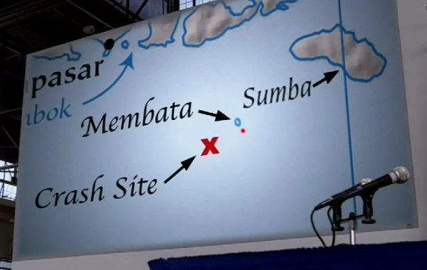
+ | '''[[wikipedia:Membata|Membata]]''' is an uninhabited island in [[Indonesia]] where the [[Oceanic Six]], as part of their cover story, claimed to have floated to shore and spent [[108]] days after the crash of [[Oceanic Flight 815]]. According to maps presented at the [[Oceanic Six press conference]], it is located in the [[Lesser Sunda Islands]], to the northeast of the alleged crash site, and to the southwest of the real Indonesian island of [[Sumba]]. {{crossref|4x12}} After the Oceanic Six (plus [[Frank Lapidus]] and [[Desmond Hume]]) were rescued by Penny's boat the ''[[Searcher]]'' in the South Pacific, they traveled some 3000 miles (one week by boat) to near Membata, from where the Oceanic Six paddled a [[Life raft|raft]] to Sumba to stage their rescue. {{crossref|4x13-14}} |
{{clear}} |
{{clear}} |
||
| + | |||
==Trivia== |
==Trivia== |
||
| − | + | {{I|I=Membata-Island.jpg|w=300|a=right|c=Location on Google Earth according to "numbers" co-ordinates.}} |
|
| + | *Membata is a fictional island. |
||
| − | *''Membata-bata'' is Indonesian for "(to be) ambivalent" or "(to be) in doubt". |
+ | *''Membata-bata'' is a word from an Indonesian language for "(to be) ambivalent" or "(to be) in doubt". |
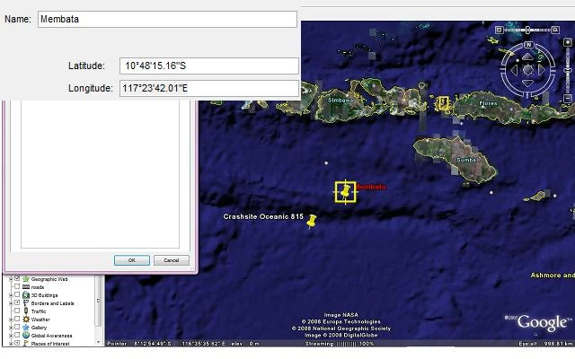
*Entering the "numbers" co-ordinates 10°[[4]][[8]]'[[15]].[[16]]"S / 117°[[23]]'[[42]].01"E into Google Earth discloses a location close to where Membata is depicted in the conference maps. |
*Entering the "numbers" co-ordinates 10°[[4]][[8]]'[[15]].[[16]]"S / 117°[[23]]'[[42]].01"E into Google Earth discloses a location close to where Membata is depicted in the conference maps. |
||
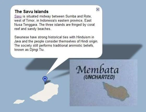
*Membata has the same shape as the main island in the Savu Island group, located to the southeast of Sumba. |
*Membata has the same shape as the main island in the Savu Island group, located to the southeast of Sumba. |
||
| − | + | {{I|I=Membata_Savu.jpg|w=240|a=left|c=Membata-Savu comparison.}} |
|
| − | |||
{{Nav-Locations}} |
{{Nav-Locations}} |
||
| − | |||
| ⚫ | |||
[[de:Membata]] |
[[de:Membata]] |
||
| Line 18: | Line 17: | ||
[[fr:Membata]] |
[[fr:Membata]] |
||
[[pl:Indonezja]] |
[[pl:Indonezja]] |
||
| ⚫ | |||
| + | [[Category:Locations]] |
||
Revision as of 00:03, 16 June 2011
Press conference map showing Membata's location. ("There's No Place Like Home, Part 1")
Membata is an uninhabited island in Indonesia where the Oceanic Six, as part of their cover story, claimed to have floated to shore and spent 108 days after the crash of Oceanic Flight 815. According to maps presented at the Oceanic Six press conference, it is located in the Lesser Sunda Islands, to the northeast of the alleged crash site, and to the southwest of the real Indonesian island of Sumba. ("There's No Place Like Home, Part 1") After the Oceanic Six (plus Frank Lapidus and Desmond Hume) were rescued by Penny's boat the Searcher in the South Pacific, they traveled some 3000 miles (one week by boat) to near Membata, from where the Oceanic Six paddled a raft to Sumba to stage their rescue. ("There's No Place Like Home, Parts 2 & 3")
Trivia
Location on Google Earth according to "numbers" co-ordinates.
- Membata is a fictional island.
- Membata-bata is a word from an Indonesian language for "(to be) ambivalent" or "(to be) in doubt".
- Entering the "numbers" co-ordinates 10°48'15.16"S / 117°23'42.01"E into Google Earth discloses a location close to where Membata is depicted in the conference maps.
- Membata has the same shape as the main island in the Savu Island group, located to the southeast of Sumba.
Membata-Savu comparison.